Applications


 Surveillance

UAV technology has proven itself one of the most valuable elements in observation and surveillance missions. UAV technology, along with the use of thermal and visual cameras, provides all the information needed when working in dangerous scenarios, such as night operations or hazardous zones.
Airelectronics systems have been designed to handle this missions and all the elements involved in them. The new U-Station, developed for this purpose, manages both the real time video feed and telemetry link, meanwhile its single enclosure with the integrated battery system makes the whole system easily transportable and really quickly to deploy.
U-See software is capable of manage the video stream itself, with no need of third software running on the computer.
Payload
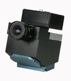
Airelectronics U-Camera
U-Camera is a gyrostabilized payload suitable for small and medium sized uavs. Designed to be small and lightweight it can be integrated in hand-launched vehicles.
- Gyro stabilized image independent of platform maneuvers and vibrations.
- 0.5 kg
- FPGA architecture
- 10X Optical Zoom.
- Safe mode for take-off and landing.
- Compatible with both rotary and fixed wing vehicles.
- Mounting flexibility.
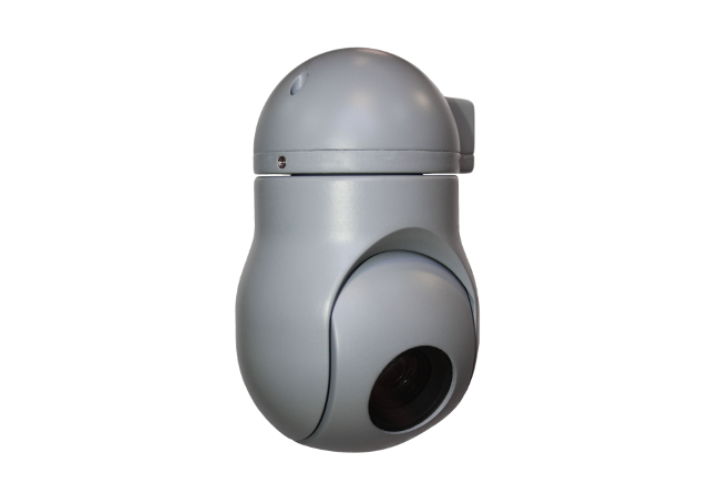
Controp T-Stamp

The STAMP payloads are miniature, lightweight, electro-optical, stabilized, airborne sensors which are designed to be carried by a miniature UAV, for tactical "Over-the-Hill" reconnaissance in daylight and / or at night.
- Gyro stabilized image independent of platform maneuvers and vibrations.
- 2.8 kg
- High performance image resolution and quality.
- Continuous Optical Zoom.
- LOS data on video signal.
Controp D-Stamp
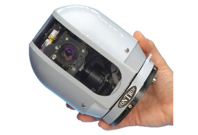
The STAMP payloads are miniature, lightweight, electro-optical, stabilized, airborne sensors which are designed to be carried by a miniature UAV, for tactical "Over-the-Hill" reconnaissance in daylight and / or at night.
- Gyro stabilized image independent of platform maneuvers and vibrations.
- 0.65 kg
- High performance image resolution and quality.
- Continuous Optical Zoom.
- LOS data on video signal.
- Mounting flexibility.
- LOS data on video signal.
Raven-640-Analog 25µm

The Raven-640-Analog 25µm is an infrared imaging camera, specially designed for the demanding security market. The thermal image is crisp and clearm even under difficult weather conditions and in complete darkness without the use of additional illumination.
- Uncooled microbolometer array
- 8 to 14 µm sensitivity
- 640 x 480 on 25µm pixel pitch
- Frame rate max. 30Hz NTSC
- Analog output (PAL or NTSC)
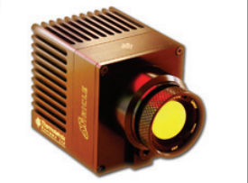
DRS TAMARISK 320

Featuring a compact, lightweight design and low power consumption, DRS TAMARISK™320 Thermal Cameras are ideal for producing high quality images in a variety of environments and applications in the 8 - 12μm range.
- Compact and Lightweight 320 x 240 Imager
- Featuring an Integrated Lens Available in a Range of Focal Lengths
- Analog or Camera Link Output
Tau 640
Tau 640: an incredibly small thermal imaging camera with 17-micron pixel pitch, and VGA resolution.
- 17-micron pixel size
- ~1 W power dissipation
- Up to 200g shock tolerance
- Lenses sealed to IP-67
Starlight 3D-DNR Sony CCD 650TVL
- 1/3'' 650TVL SONY Super HAD CCD II
- 0.001 LUX Starlight(Sense-up x512)
- 3 Dimension Digital Noise Reduction(3D-NR)
- FOV 94° 2.8mm lens
- 25mm x 25mm x 28mm(Lens)
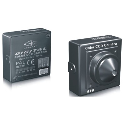
CM-3125CH
- 1/3" Sony Super HAD CCD
- 0.1 lux minimum illumination
- 3.6mm board lens
- 540 TV Line Horizontal Resolution
- 25mm x 25mm x 28mm(Lens)
Avionics
U-Pilot

This is the heart of our system, as it is the on-vehicle hardware. We produce it in two distinct variants: The fixed wing and rotary wing hardware
- Its hardware architecture is safe by design: a CPU is solely dedicated to fly the plane without making any blocking operation.
- Top of the line MEM sensors: up to ±16G and 2000 °/s dynamics detection
- Up to 26 PWM outputs and 8 RS-232 or 4 RS-485 serial port for all your needs.
- Automatic return home functionality in case of loss of COMMs. Either direct or planned backtrack route configurable in real-time
U-Pilot OEM
Slim version of U-Pilot suitable for small airplanes. It's also produced in two variants: The fixed wing and rotary wing hardware
- Slim design for a minimum volume ocupation
- Its hardware architecture is safe by design: a CPU is solely dedicated to fly the plane without making any blocking operation.
- Up to 100 km of data-link range
- Great GPS performance with its on-board 184 channel receiver and RTK support
U-Station

U-Station provides stable video and data links due to its antenna set integrated in a single device that allows an easy deployment and pointing.
- Up to 100 km omnidirectional data-link
- Low power consumption
- Interfaces with standard Futaba Trainer Port. Your pilot will be already familiar with the controller
- Integrated battery
Software
U-See

U-See is capable of handling video streams and will add the information about the pointed location over the video.
- Additional information
- Flight pattern generator
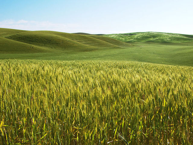
Remote Sensing

Remote sensing refers to the acquisition of information about something without actually making any physical contact with it. This technique is commonly used in various areas, such as in forestry, agriculture, and environmental applications like desertification, soil erosion, and water quality. Remote sensing has been proven very successful in the agriculture area, providing accurate information about the plants physiological status and water stress condition.
For these purposes, thermal and multi/hyper-spectral cameras are widely used, acquiring spectral information the visible and near-infrared ranges. With the combination of information from different spectral bands, the user is able to retrieve valuable data regarding the plant status and stress levels, using indicators such as the Normalized Differential Vegetation Index NDVI,Photochemical Reflectance Index (PRI), chlorophyll indices, and water stress indicators.
Remote sensing technology enables the study of soil, plants and water properties from unmanned aerial vehicles, reducing the cost of operation.
Airelectronics brings its own experience providing U-Pilot capable of managing Thermal / Multi / Hyper-Spectral cameras, triggering the systems fully synchronized or sequentially, as required. The images are saved onboard, while the telemetry is sent to the U-Ground to generate a file including imagery geolocation and vehicle attitude information. U-See software also provides a flightplan generator that will automatically design a flightplan to overfly a defined area.
This information is provided through a software specifically designed to manage the remote sensing imagery acquisition along with auxiliary data, enabling the generation of fully calibrated orthomosaics. The remote sensing imagery of the selected study areas can be processed to calculate indices such as NVDI, PRI, TCARI/OSAVI and thermal-related water stress indicators such as CWSI, among others.
Payload
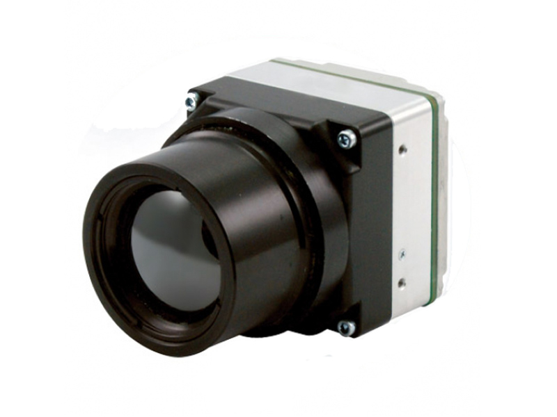
Miricle 307ks Thermal Camera
With low weight and low power consumption Miricle is ideal for applications such as UAV, man-portable surveillance, driver aids and enhanced vision systems for aircraft.
- 640x480 pixels
- 8um-12um spectral response
- 50/60/240 FPS
- 3.7 Watts
- -20 to +50 ºC
- 166 gr
- Waterproff ruggedised unit
- Airelectronics offers the required calibration with black body
Headwall Photonics VNIR
Headwall's Hyperspec VNIR family of integrated hyperspectral imaging sensors provides the foundation for utilizing hyperspectral imaging to achieve superior spectral sensing and chemical imaging results for the mission.
- 400 - 1000 nm wavelenght
- Silicon CCD
- 12-23 FPS
- 10 to 40 ºC
- 12 bits
- 2.9 kg
Tetracam ADC Lite

The primary use of this product is the recording vegetation canopy reflectance. The resulting image is suitable for derivation of several vegetation indices.
- 2048x1536 pixels
- Green, Red and NIR sensitivity with bands approximately equal to TM2, TM3 and TM4
- 8 and 10 bits RAW formats
- 114mm x 77mm x 22mm
- 200 gr
- Airelectronics offers the required calibration with integrating sphere
Tetracam Mini-MCA

Mini-MCA is a configurable spectroscope able to detect vegetation in varying states of health or distinct stages of growth.
- 1280x1024 pixels
- 1 CMOS sensors per channel
- 8 and 10 bits RAW formats
- 115mm x 78mm x 80mm
- 700 gr
- Airelectronics offers the required calibration with integrating sphere
Avionics
U-Pilot
This is the heart of our system, as it is the on-vehicle hardware. We produce it in two distinct variants: The fixed wing and rotary wing hardware
- Its hardware architecture is safe by design: a CPU is solely dedicated to fly the plane without making any blocking operation.
- Top of the line MEM sensors: up to ±16G and 2000 °/s dynamics detection
- Up to 26 PWM outputs and 8 RS-232 or 4 RS-485 serial port for all your needs.
- Automatic return home functionality in case of loss of COMMs. Either direct or planned backtrack route configurable in real-time
U-Pilot OEM
Slim version of U-Pilot suitable for small airplanes. It's also produced in two variants: The fixed wing and rotary wing hardware
- Slim design for a minimum volume ocupation
- Its hardware architecture is safe by design: a CPU is solely dedicated to fly the plane without making any blocking operation.
- Up to 100 km of data-link range
- Great GPS performance with its on-board 184 channel receiver and RTK support
U-Ground

The ground hardware will interface to your antennas and PC (running our software) to be able to interface with the on-board hardware
- Up to 100 km of data-link
- Low power consumption
- Interfaces with standard Futaba Trainer Port. Your pilot will be already familiar with the controller
Software
U-Mosaic

U-Mosaic software uses the data from U-Pilot and U-See to project the taken pictures on the ground. This tool makes possible to analyze the data and detect any errors prior to the processing with third party software.
- Georeferred projection of the taken pictures.
- Simple interface, no configuration required.
- Export to several formats; Pix4D, Agisoft, ...
- Compatible with U-See software and Airelectronics systems.
U-See

With the purchase of our ground software you buy a license to use the software in any computer you want (under MacOS X, Windows or Linux). You are limited to use the program in only one computer at a time, as we use a USB dongle that will check the license.
- Maps from the Internet. There is no need to download the maps before the use.
- Simple program interface. Easy configuration and use.
- A one-click destination mode is implemented in all modes across all the vehicles. Have you seen something that deserves more detail? Send the UAV there!
- What is shown in the screen is always what the UAV has on its on-board systems. You don’t have to think if you uploaded the flight plan. If you see it on screen, it is on plane.
Remote Sensing Software Bundle

The image processing chain is provided by a dedicated software that conducts all the required calibrations and data calculations. The software performs the radiometric calibration,atmospheric correction and image stitching to obtain fully calibrated mosaics, and vegetation index calculation.
- Radiometric calibration
- Geometric calibration
- Atmospheric correction
- Image Stitching & Georeference
- Vegetation and soil index extration
Topography

Using the position and attitude data provided by the Airelectronics flight control systems, conventional photos can be used to produce 2D orthomosaic maps and 3d models of big areas.
U-Pilot manages the camera trigger, meanwhile U-Ground and U-See are collecting telemetry. After the flight is completed, U-See software will generate a data file with the positional information of the photos that had been taken, in order to provide this information to a PC software that will generate the map of the overflown zone.
Airelectronics suggest some software and cameras that have been proven to work successfully, but any other camera/software combination can be used (U-Pilot can handle a large number of triggering system and U-See uses standard formats to export the geopositioning and attitude information).
U-See software has some features specifically designed for this kind of application, such as the flightplan generator, that will make a lot easier to design a flightplan for big study areas or the shotting interval configuration, providing the ability to adapt the timming to the altitude and speed of the flight.
These maps provide valuable information for many applications, such as mining, topography, agriculture or aerial imagery.
Payload
Panasonic DMC LX5

Point-and-shoot camera with high sensibility CCD with LEICA DC VARIO-SUMMICRON lens.
- 10.1-megapixel
- 1/1.63-inch, High Sensibility CCD
- Venus FHD Engine with Intelligent Resolution technology
- 109.7mm x 65.5mm x 43 mm
- 271 gr
Sony NEX-7

Mirrorless interchangeable lens camera with a smaller body form factor than a traditional digital single-lens reflex camera.
- 24.3-megapixel
- 23,5 x 15,6 mm Sensor CMOS Exmor APS HD
- Venus FHD Engine with Intelligent Resolution technology
- 119,9mm x 66.9mm x 42.6 mm
- 291 gr + Lens
Canon PowerShot A810

Compact point-and-shoot camera with high sensibility CCD.
- 16-megapixel
- 1/2.3 pulgadas Sensor CCD
- 4.608 x 3.456 px resolution
- 94,7mm x 61,3mm x 29,8 mm
- 171 gr
Avionics
U-Pilot
This is the heart of our system, as it is the on-vehicle hardware. We produce it in two distinct variants: The fixed wing and rotary wing hardware
- Its hardware architecture is safe by design: a CPU is solely dedicated to fly the plane without making any blocking operation.
- Top of the line MEM sensors: up to ±16G and 2000 °/s dynamics detection
- Up to 26 PWM outputs and 8 RS-232 or 4 RS-485 serial port for all your needs.
- Automatic return home functionality in case of loss of COMMs. Either direct or planned backtrack route configurable in real-time
U-Pilot OEM
Slim version of U-Pilot suitable for small airplanes. It's also produced in two variants: The fixed wing and rotary wing hardware
- Slim design for a minimum volume ocupation
- Its hardware architecture is safe by design: a CPU is solely dedicated to fly the plane without making any blocking operation.
- Up to 100 km of data-link range
- Great GPS performance with its on-board 184 channel receiver and RTK support
U-Ground
The ground hardware will interface to your antennas and PC (running our software) to be able to interface with the on-board hardware
- Up to 100 km of data-link
- Low power consumption
- Interfaces with standard Futaba Trainer Port. Your pilot will be already familiar with the controller
Software
U-Mosaic
U-Mosaic software uses the data from U-Pilot and U-See to project the taken pictures on the ground. This tool makes possible to analyze the data and detect any errors prior to the processing with third party software.
- Georeferred projection of the taken pictures.
- Simple interface, no configuration required.
- Export to several formats; Pix4D, Agisoft, ...
- Compatible with U-See software and Airelectronics systems.
U-See
With the purchase of our ground software you buy a license to use the software in any computer you want (under MacOS X, Windows or Linux). You are limited to use the program in only one computer at a time, as we use a USB dongle that will check the license.
- Maps from the Internet. There is no need to download the maps before the use.
- Simple program interface. Easy configuration and use.
- A one-click destination mode is implemented in all modes across all the vehicles. Have you seen something that deserves more detail? Send the UAV there!
- What is shown in the screen is always what the UAV has on its on-board systems. You don’t have to think if you uploaded the flight plan. If you see it on screen, it is on plane.
Photomodeler

PhotoModeler helps you create accurate, high-quality 3D models and measurements from photographs using an standard camera.
- CAD-like model creation
- Perform accurate measurements
- Print and use Coded Targets
- Models using points, lines, edges, surfaces (photo textured or shaded) and other entities.
Pix4D

Pix4D is your solution to convert thousands of aerial images, taken by lightweight UAV or aircraft into geo-referenced 2D mosaics and 3D surface models and point clouds.
- Camera autocalibration
- UAV-optimized Automatic Aerial Triangulation
- Point Cloud densification
- Rapid processing mode
- Geo-referenced orthomosaics in GeoTIFF
 (+34) 608-99-11-52
  info@airelectronics.es
 Science and Technology campus of Montegancedo
28223, Pozuelo de Alarcón
Madrid, Spain